On 21 April 1855, William C. Sharp purchased 160 acres of land in North East 1/4
of Section 10 in Township 14 South Range 6 East, near the town of Tansill in Pope County, Illinois from
Benjamin and Lucinda Belford for 500 dollars. A transcription of the deed and maps showing the location follow the images.


[MS page 117]
This Indenture made and entered into
this twenty first day of April one thousand eight
hundred and fifty five between Benjamin Belford
and Lucinda Belford his wife of the County of Pope
and State of Illinois of the first part and William
C. Sharp of the same County and State aforesaid of
the second part witnesseth that the said party of
the first part for an In consideration of the sum
of five hundred dollars current money of the United
States in hand paid by the party of the second
part the receipt whereof is hereby acknowledged have
granted bargained sold conveyed and confirmed and
by these presents doth grant bargain sell convey and
confirm unto the said party of the second part his
heirs and assigns forever all their interest in and to
a certain tract of land or lot of ground situated lying
and being in the County of pope and State of Illinois
and bounded as follows to wit the North east quarter
of Section No. 10 in township No. 14 South range 6 east
containing One hundred and sixty acres more or less
and entered in the name of William Cowan on
the fourth day of March 1818. To have and to hold the
aforesaid tract of land or lot of ground together withall
and singular the right profits tenements and heradet-
himents[hereditaments] apperlinances[appurtenances] thereunto belonging or in anywise
thereunto appertaining to the only proper use benefit
and behoof of the said William C. Sharp the said
party of the second part his heirs and assigns forever
and the said party of the first part do covenant and
agree To warrant and defend the said tract of land
To him the said party of the second part his heirs
and assigns and against the claims of them the said
party of the first part their heirs and assigns and
against the claim or claims of any other person or per-
sons whomsoever. In testimony whereof the party of
the first part hereunto set their hand and seals this
day and year above written signed sealed and delivered
Benj Belford {seal}
State of Illinois } Lucinda her x mark Belford {seal}
Pope County }
This day personally appeared before
the undersigned a Justice of the peace in and for
said County and State aforesaid Benjamin Belford
and Lucinda Belford wife of Benjamin to me
personally known and on the day of the date hereof
acknowledged the foregoing dead of conveyance as
of their free and voluntary act and deed for the
[MS page 118]
the purposes therein expressed and the said Lucinda wife
of the said Benjamin Belford having been by me examined
separate and apart from her said husband she then again
acknowledged the same freely and voluntary and said she
done so without the threat compulsion or persuasion of her
said husband and that she freely and voluntary relinquished
her dowry in said primises[premises] in Testimony hereof I have here-
unto set my hand and seal this 21st day of April A.D. 1855
Wm Belford J P
Recorded this 24 April 1855
Jno RaumClerk Circuit
Court & Ex officio Recorder
Reference Notes:
Pope County, Illinois, Deed Records, Series A, 1816-1883, G:117-118, Benjamin Belford to William C. Sharp, 21 April 1855; recorded 24 April 1855; Pope County Clerk & Recorder, Golconda.
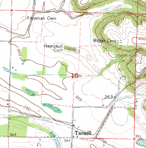
U.S. Department of the Interior, Geological Survey Topographic Map: Illinois-Kentucky, Brownfield Quadrangle, 7.5' series, 1962. [Map 1 below]
U.S. Department of the Interior, Geological Survey Topographic Map: Illinois-Kentucky, Brownfield Quadrangle, 15' series, 1917. [Map 2 below]
Commentary:
When the Sharp family sold their Rising Sun, Indiana property, the sale deed (dated 25 August 1853), was completed in Pope County, Illinois although they left their county and state of residence as blank. Then a subsequent sale deed for the same property and grantee, gave their residence as Pope County, Illinois in 1854. So they had been in the area for at least 2 years before acquiring this property.
The location of the property is clearly shown on the U.S. Geological Survey Topographic Maps. The section grid lines are superimposed on these maps and they are 1 mile by 1 mile. Below are two snippets of the maps showing only section 10. The property described in the deed is the northeast quarter of this square.
The older map below, shows the roads existing in 1914-15. It also shows buildings at two locations in the northeast quarter. These are possible sites for the William C. Sharp homestead.
The location of the property is clearly shown on the U.S. Geological Survey Topographic Maps. The section grid lines are superimposed on these maps and they are 1 mile by 1 mile. Below are two snippets of the maps showing only section 10. The property described in the deed is the northeast quarter of this square.
 |
| Map 1 - Section 10, T14S, R6E, Pope Co., IL (1962) |
 |
| Map 2 - Section 10, T14S, R6E, Pope Co., IL (1917) |
No comments:
Post a Comment